Revolutionizing Urban Planning: Unreal Engine Digital Twin for Caloundra Transport Corridor Upgrade
In the dynamic realm of urban development, communicating intricate engineering designs effectively to both professionals and the public is crucial. During my tenure as a Senior Developer at Aurecon, I spearheaded the creation of a real-time digital twin visualization for the Caloundra Transport Corridor Upgrade (CTCU) project using Unreal Engine. This cutting-edge solution enhanced collaboration among engineers, engaged the community, and provided an immersive visualization of the proposed infrastructure improvements.
Project Overview
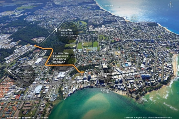
The CTCU is a significant infrastructure project aimed at improving connectivity and easing congestion in Caloundra. The 1.6-kilometer corridor will provide better access to the Caloundra CBD while reducing traffic bottlenecks on key arterial roads, such as the Nicklin Way and Pelican Waters Boulevard. This project is designed to accommodate current and future needs for motorists, cyclists, pedestrians, and public transport users.
By leveraging innovative visualization technologies, we elevated the project’s communication strategy, ensuring all stakeholders had a clear and comprehensive understanding of the design and its impact.
The Power of Unreal Engine and Digital Twin Technology
To bring this ambitious project to life, we used Unreal Engine to create a highly detailed and interactive digital twin. This real-time application served as a virtual replica of the proposed corridor, enabling stakeholders to explore the design interactively. Key features of the digital twin included:
- Detailed Infrastructure Models: The visualization incorporated road layouts, intersections, pedestrian pathways, and landscaping, providing a holistic view of the project’s design.
- Real-Time Adjustments: With Unreal Engine’s real-time rendering capabilities, engineers could visualize design iterations immediately, streamlining collaboration and decision-making.
Augmenting the Digital Twin with Geospatial Data
To ensure the digital twin was contextually accurate and visually compelling, we integrated geospatial data using several powerful tools and platforms:
- Cesium and Google Maps API: These tools were used to populate the digital twin with high-quality, real-world surroundings. This provided a realistic sense of the corridor’s broader environment and its integration into the existing landscape.
- Nearmap: For areas immediately surrounding the corridor, we used Nearmap’s high-resolution aerial imagery. This allowed us to provide a more detailed and visually striking representation of nearby structures, roads, and terrain.
By incorporating these datasets, we enhanced the accuracy and realism of the digital twin, making it a highly effective tool for engineers and stakeholders alike.
Enhancing Engineering Collaboration
The digital twin was not just a visualization tool—it was a bridge between data and design. Using GIS data and engineering schematics, we ensured that every aspect of the visualization was grounded in reality. Engineers could interact with the model, assess design decisions, and collaborate across disciplines in a way that was previously impossible.
The integration of high-quality geospatial data and engineering models provided a unified platform where stakeholders could evaluate the project’s impact comprehensively. This level of collaboration was instrumental in refining the design and addressing potential challenges early in the process.
Engaging the Community through VR
Community engagement was a central focus of this project. To address public concerns and provide transparency, we incorporated Virtual Reality (VR) capabilities into the digital twin.
Using VR, community members could:
- Virtually Navigate the Corridor: Experience the proposed changes firsthand in an immersive environment.
- Understand the Project’s Impact: Gain a clearer perspective on how the upgrades would improve connectivity and reduce congestion.
- Provide Feedback: Share their thoughts and concerns, which were invaluable for refining the design and addressing public apprehensions.
This approach not only built trust but also fostered a sense of inclusion, ensuring the project addressed both technical and community needs.
Outcomes and Reflections
The CTCU project demonstrates the transformative potential of digital twin technology in urban planning and infrastructure development. By integrating Unreal Engine with advanced geospatial tools like Cesium, Google Maps API, and Nearmap, we created a visualization platform that was as informative as it was immersive.
Key Achievements:
- Enhanced Collaboration: Engineers and stakeholders benefited from a unified platform for decision-making and design evaluation.
- Informed Community Engagement: VR and real-time visualization tools provided the public with an accessible and clear understanding of the project’s benefits.
- Real-Time Adjustments: The ability to make immediate design changes in a virtual environment saved time and resources.
This project highlights how technology can bridge the gap between complex engineering concepts and public comprehension, paving the way for more inclusive, transparent, and effective project delivery.
By combining cutting-edge tools like Unreal Engine, Cesium, Google Maps API, and Nearmap, we not only enhanced the planning process but also set a new standard for how large-scale infrastructure projects are communicated and developed. This was a truly collaborative effort that underscores the value of integrating real-time applications and digital twin technology into urban planning and community engagement.
